Reports
Final Report on Department of Agriculture and Water Resources funding to support legacy soil data capture through the Australian Collaborative Land Evaluation Program (ACLEP)
 ACLEP has been working with state/territory agencies for many years to digitally capture, collate and disseminate soil data in a nationally consistent form. The Department of Agriculture and Water Resources provided $55,000 of National Landcare Programme funding through ACLEP to support the digitisation of some priority legacy data sets by states and for provision of that data to ASRIS. This included –
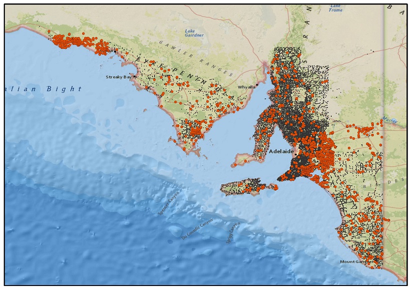
- South Australia – digital capture of approximately 650 soil site data particularly from non-farmed rangelands, Eyre and Yorke Peninsulas, Murraylands and the viticultural regions.
- Queensland – capture of soil mapping and associated data in the Desert Uplands, Haughton, Collinsville, Emerald and Burnett areas.
This project has supported the capture of locally and regionally significant soil data sets which can be used to underpin land development and management decisions related to agriculture, rangelands and mining interests amongst other purposes.
Download the report.
A strategic framework to improve phosphorus management in the Australian grains industry
 This report provides a review of key phosphorus management issues on-farm in the Australian grains industry and develops a strategic framework to respond to these issues and improve efficiency, profits and sustainability.
Use of phosphorus (P) fertilisers is critical for agricultural productivity, profitability and food security. However, concerns are increasing in Australia about the security of global supplies of P, rising fertiliser prices and the potential for adverse environmental impact associated with P use. These concerns prompted this assessment of P management in Australian agriculture. We focused on the grains industry because it is one of the largest users of P in Australia. Together with sugar, rice and cotton, they account for ~65% of the 453 kt of P fertilisers currently used annually in Australian agriculture.
This analysis of P use is based on recently published research plus data from the Australian Bureau of Statistics. It identifies the potential to improve P management in the short, medium and long term through tactical and strategic interventions to improve profits and sustainability.
Download the report.
National soil condition monitoring for soil pH and soil carbon
 This report presents: operating procedures and guidelines for national soil condition monitoring, testing of the methodology, a proposed program governance structure, selected priority monitoring units, a statistical model and program cost estimates.
A national soil condition monitoring program is critical to understanding how Australia’s soil resources are being affected by agricultural management practices and climate change. The program is designed around three key questions: 1) what are the magnitudes and directions of soil organic carbon and soil pH changes for representative soil and land use combinations? 2) what are the levels of certainty (statistical confidence) associated with the measured soil carbon and pH changes? 3) what can be inferred about the changes in soil carbon and pH across different environments and the influence of land use and/or land management? Is Australia’s soil resource degrading, maintaining or improving under current agricultural systems?
Download the report.
Improving Australian soil data and information governance
 Appropriate soil data and information are essential to support evidence based policy, planning and resource management decisions.
Data governance is important to improve the long-term management and use of strategic corporate data and information assets. A primary goal of data governance is to establish processes, people and technology to efficiently and effectively manage authoritative, fundamental data and information so that it can be readily discovered, accessed and used by many. Governance defines who has rights and responsibilities and who makes decisions regarding content, access and use of data and information assets.
Improving national governance arrangements is the most important step towards establishing a solid foundation for improving the accessibility and use of Australian soil data and information.
Download the report.
Digital Soil Mapping in ACLEP 2012 and beyond
 Digital soil mapping (DSM) refers to the computer-aided analyses and prediction of soil properties (e.g. pH, clay content) and/or soil classes. DSM uses measured soil data with remote and proximal sensing, elevation and terrain parameters and a range of (geo)statistical modelling to predict the characteristics of soil across landscapes. Products derived from DSM processes incorporate quantitative estimates of uncertainty, which conventional soil mapping does not.
This report examines the new technologies and methodologies for measuring and predicting soil attributes that has facilitated recent advances in DSM, which addresses a globally recognised need for current, accurate, spatially referenced soil information. This need has been expressed by the modelling community, natural resource managers and policy and decision makers. There is an immediate need to operationlise DSM within a reinvigorated soil data and information program across Australia and to support modelling approaches that take advantage of new quantitative soil data.
Download the report. Download appendix 1 (DSM workshop manual) and appendix 2 (Tasmanian DSM Project Report)
Digital Soil Mapping Workshop 2010
 The 4th Global Workshop on Digital Soil Mapping, held 24–26th May 2010 in Rome, provided an invaluable opportunity for state, territory and federal agency representatives to consider new approaches for developing land and soil information via the use of DSM techniques. The report provides a summary of the workshop and key recommendations for the advancement of digital soil assessment in Australia.
Download the report. Download the workshop manual.
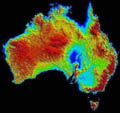
Physiographic Regions of Australia
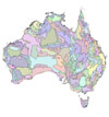 The report gives an overview of physiographic mapping in Australia, describes current methods for mapping and provides a brief description of Australia’s landscapes and the regions that have been defined. The audience will range from those who are looking for a brief description of the physiography of Australia to those who will use the data for integrated studies of the environment.
The report and digital data set are available for download from the Australian Soil Resource Information System.
ASRIS/ACLEP User Needs Analysis
 This report documents a project to assess ‘existing needs’ of key users of the Australian Soil Resources Information System (ASRIS). The project was not an exhaustive evaluation of all users’ requirements nor was it a technical review of the ASRIS delivery mechanism.
ACLEP commissioned this report to provide direction for the future development of national soil data products that would meet specific user requirements and be applicable to a broad range of soil data users. In particular, to identify the attributes of soil that would be most relevant to specific needs. Download the report.
Managing Australia’s Soils: A policy discussion paper Summary of submissions from public consultation
 In 2006, The National Committee on Soil and Terrain (NCST) requested agreement from the Natural Resource Policies and Programs Committee (NRPPC) to develop a strategic approach to managing Australia’s soil and land resources.
In October 2008, the 83-page discussion paper, Managing Australia’s Soils: A policy discussion paper, prepared by Andrew Campbell, was sent to approximately 450 stakeholders for comment. Download the full report or the executive summary.
Soil Policy Discussion Paper
 Managing Australia’s Soils: a policy discussion paper (PDF - 7MB) raises a range of issues related to sustainable soil management and seeks public input to develop a strategic and forward-looking approach to the management of this important resource.
ACLEP Annual Reports
ASRIS Reports
Contributing data to ASRIS (PDF - 1MB)
Online data delivery to ASRIS (PDF - 1MB)
ASRIS Technical Specification v1.6 (PDF - 3MB)
Soil Archive Reports
Archive Activities 2011-2012 (PDF - 2MB)
Soil Information Transfer and Evaluation System (SITES v2) (Documentation and Database - 2MB)
Other Publications
Soil Monitoring
National soil condition monitoring for soil pH and soil carbon: objectives, design, protocols, governance and reporting ( PDF - 2 MB)
Building a foundation for soil condition assessment (PDF - 3MB)
Monitoring Soil Change - Principles and practices for Australian conditions (PDF - 5MB)
Estimating Water Storage Capacities
Estimating water storage capacities in soil at catchment scales (PDF - 1MB)
ACiL Benefit-Cost Analysis Report
The Development of a Framework and Instruments for Assessing the Benefits and Costs of Land Resource Assessment in Australia (PDF - 0.5MB)
Estimation of Soil Properties
Estimation of Soil Properties Using the Atlas of Australian Soils (PDF - 1MB)
United States Department of Agriculture
Soil Survey Photography - Principles and Techniqures (PowerPoint Presentation - 30MB)