About ACLEP
The Australian Collaborative Land Evaluation Program (ACLEP) was established in 1992 and is a proven model for national cooperation, collaboration and effective multi-jurisdictional activity. ACLEP is a partnership between CSIRO Land and Water, the Australian Government Department of Agriculture and the state and territory agencies responsible for land resource assessment. It provides a focus for the collection, collation, management, dissemination and analysis of nationally consistent, integrated data and information on soil and land resources. It provides input to national assessments of the consequences of land resource use and management (Figure 1).
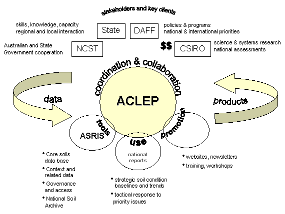
Figure 1: ACLEP a national collaboration providing fundamental data and policy relevant information.
ACLEP delivers on a vision that “natural resource management in Australia is underpinned by appropriate soil and land resource information and knowledge to ensure sustainable economic and environmental systems”.
ACLEP is currently funded by the Australian Government Department of Agriculture and CSIRO. States and territories provide significant resources in support of ACLEP projects and activities. ACLEP is managed through the CSIRO National Soil Information Centre and is directed and coordinated through the National Committee for Soil and Terrain (NCST). The NCST has representatives from all State, Territory and Australian Government agencies with mandated responsibility for soil and land information. DAFF provides secretariat support to the NCST.
Objectives
The long term objectives of ACLEP are to ensure:
- Users needs and demands for soil and land resource information are clearly defined and addressed
- The spatial and temporal coverage of soil and land resource information for Australia is complete at an agreed and appropriate resolution
- Soil and land resource information is readily accessible and able to be used effectively
- Soil and land resource information provides estimates of key attributes controlling landscape processes and functions that are relevant to natural resource management
- Condition and trend of soil and land resources are known and reported for all regions of Australia.
Priorities
The ACLEP workplan delivers a strategic information infrastructure which both builds national capacity and provides strategic support for emerging priorities.
The workplan is developed through a program logic approach that:
- Builds coordination and partnerships
- Promotes standards and guidelines
- Delivers ASRIS the national soil information infrastructure
- Maintains upload of historic data to ASRIS
- Facilitates filling major data gaps through digital soil mapping
- Strengthens The National Soil Archive
- Develops national reports Improves communications and promotion
- Supports skills and capacity building