News Archive
News stories, events and announcements previously featured on our home page are archived here. Newest entries appear at the top.
 |
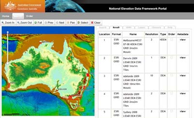
National Elevation Data Framework Portal The NEDF-Portal has been developed to serve as a 'Virtual Data Repository' and on-line portal that allows easy discovery and access to existing elevation data holdings and metadata. The NEDF-Portal will progressively be populated with data and links to national, state, local and commercial data custodians.
Download and/or order SRTM derived products at 1 second (government agencies) and 3 second through the portal. Currently the Digital Surface Model (DSM), Digital Elevation Model (DEM) and Hydrological Digital Elevation Model (DEM-H) are available. Additional terrain attribute surfaces (slope, aspect, relief, plan and profile curvature, contributing area) will be available in the coming months. |
 |
ACLEP Digital Soil Mapping Training – The University of Sydney 21-23 February 2011 Digital soil mapping (DSM) involves a range of innovative software and modelling approaches to develop relationships between soil classes and individual properties and a number of environmental covariates. These relationships can then be used to predict the spatial pattern of soil classes and properties across the landscape. The Australian Collaborative Land Evaluation Program (ACLEP) arranged for the world leading Sydney University to deliver an introductory DSM training course to a number of federal and state agency representatives. A total of 19 agency representatives from all states and territories (except the ACT) and Geosciences Australia and the CSIRO were involved. The three day technical course was developed and delivered by Sydney University lecturers Brendan Malone, Budiman Minasny and Ichsani Wheeler. Professor Alex McBratney added sessions on digital soil mapping concepts and principles and their application to GlobalSoilMap.net. |
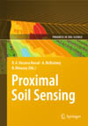 |
Proximal Soil Sensing This book reports on developments in Proximal Soil Sensing (PSS) and high resolution digital soil mapping. PSS has become a multidisciplinary area of study that aims to develop field-based techniques for collecting information on the soil from close by, or within, the soil. Amongst others, PSS involves the use of optical, geophysical, electrochemical, mathematical and statistical methods. This book is suitable for undergraduate course material and postgraduate research, brings together ideas and examples from those developing and using proximal sensors and high resolution digital soil maps for applications such as precision agriculture, soil contamination, archaeology, peri-urban design and high land-value applications, where there is a particular need for high spatial resolution information. The book in particular covers soil sensor sampling, proximal soil sensor development and use, sensor calibrations, prediction methods for large data sets, applications of proximal soil sensing, and high-resolution digital soil mapping. This publication is available from Springer for 129.95 Euro. |
 |
Digital Soil Mapping Digital Soil Mapping is the creation and the population of a geographically referenced soil database. It is generated at a given resolution by using field and laboratory observation methods coupled with environmental data through quantitative relationships. Digital soil mapping is advancing on different fronts at different rates all across the world. This book presents the state-of-the art and explores strategies for bridging research, production, and environmental application of digital soil mapping.It includes examples from North America, South America, Europe, Asia, and Australia. The chapters address the following topics: - exploring new environmental covariates and sampling schemes - using integrated sensors to infer soil properties or status - innovative inference systems predicting soil classes, properties, and estimating their uncertainties - using digital soil mapping and techniques for soil assessment and environmental application - evaluating and using legacy soil data - protocol and capacity building for making digital soil mapping operational around the globe. This publication is available from Springer for 129.95 Euro. |
 |
Digital Soil Mapping with Limited Data There has been considerable expansion in the use of digital soil mapping technologies and development of methodologies that improve digital soil mapping at all scales and levels of resolution. These developments have occurred in all parts of the world in the past few years and also in countries where it was previously absent. There is almost always a shortage of data in soil research and its applications and this may lead to unsupported statements, poor statistics, misrepresentations and ultimately bad resource management. In digital soil mapping, maximum use is made of sparse data and this book contains useful examples of how this can be done. This publication is available from Springer for 99.95 Euro. |
 |
Out of the Scientist's Garden: A Story of Water and Food Out of the Scientist's Garden is written for anyone who wants to understand food and water a little better - for those growing vegetables in a garden, food in a subsistence plot or crops on vast irrigated plains. It is also for anyone who has never grown anything before but has wondered how we will feed a growing population in a world of shrinking resources. This new publication is available from CSIRO Publishing for $29.95. Click here to read the book review. |
 |
Managing Australia’s Soils: A policy discussion paper Summary of submissions from public consultation In 2006, The National Committee on Soil and Terrain (NCST) requested agreement from the Natural Resource Policies and Programs Committee (NRPPC) to develop a strategic approach to managing Australia’s soil and land resources In October 2008, the 83-page discussion paper, Managing Australia’s Soils: A policy discussion paper, prepared by Andrew Campbell, was sent to approximately 450 stakeholders for comment (NCST letter of thanks). Download the full report or the executive summary. |
 |
The Soils of Southern South Australia This new 446 page, full-colour, South Australian Dept of Water, Land & Biodiversity Conservation (DWLBC) publication describes the soil resources of SA’s productive and diverse temperate zone (commonly known as the ‘agricultural areas’), summarising concepts and data specifically relating to soil type. In particular, the nature, diversity, distribution, limitations and potential of these resources are described. |
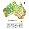 |
The Digital Atlas of Australian Soils can now be downloaded from ASRIS The Atlas of Australian Soils (Northcote et al 1960 – 68) was digitized by the Bureau of Rural Sciences in 1991 and has been available from the Australian Natural Resources Data Library for some time. Although this dataset has many limitations and there have been many efforts to provide better data, it is still in demand, primarily due to its complete coverage of the country. To assist with access to the data and to the various interpretations of the mapping units, and also provide some understanding of uses and limitations of the data, it can now also be downloaded from ASRIS. |
 |
Australian Soil and Land Survey Field Handbook (3rd Edition) is now available from CSIRO Publishing The much anticipated third edition of the Australian Soil and Land Survey Field Handbook has been released to the delight of practitioners and educators. The Field Handbook (commonly known as the ‘Yellow Book’) is an essential resource for soil scientists, ecologists, geomorphologists, educators and students and has enjoyed remarkable success as part of the popular Australian Soil and Land Survey Handbook Series which covers all aspects of land resource survey in Australia. The latest edition includes revised chapters on location and vegetation as well as some new landform elements. The Field Handbook specifies methods and terminology for soil and land surveys and is widely used throughout Australia, providing the reference set of definitions for the characterisation of landform, vegetation, land surface, soil and substrate. The 264-page book is available from CSIRO Publishing for $64.95. |
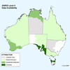 |
Significant new data uploaded to ASRIS A recent DAFF funded project has facilitated the upload of considerable additional mapped soil data to ASRIS from state and territory agencies. Data includes improved coverage and attribution of Level 4 and 5 data in Queensland, Northern Territory, Western Australia, South Australia and Tasmania. |