Soil Information Models
ACLEP has been working to develop feature based information models to support the publication and exchange of standardised soil data. A number of soil information models, expressed in UML (Unified Modeling Language) are in development to support national and international initiatives.
ANZSoilML - An Australian-New Zealand standard for exchange of soil data
ANZSoilML is a GML-based soil information model developed by CSIRO and Landcare Research (NZ) to facilitate the discovery, query and delivery of soil and landscape data. It covers the soil and landscape properties specified in the ‘Australian Soil and Land Survey Field Handbook’ and New Zealand ‘Soil Description Handbook’
ANZSoilML modifies the Australian soil exchange standard (OzSoilML) to enable delivery of data that meets the New Zealand soil information requirements.
The International Union of Soil Sciences (IUSS) Working Group on Soil Information Standards (WG-SIS) aims to develop, promote and maintain a standard to facilitate the exchange of soils data and information. ANZSoilML is proposed as a profile of the general SoilML model being progressed through WG-SIS.
When combined with community defined exchange standards such as ANZSoilML, the Open Geospatial Consortium (OGC) and International Organization for Standardization (ISO) standards allow querying and delivery of data from organisation specific databases.
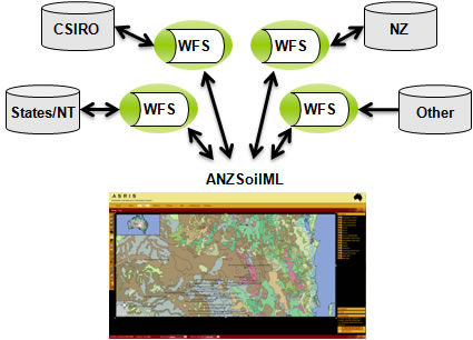
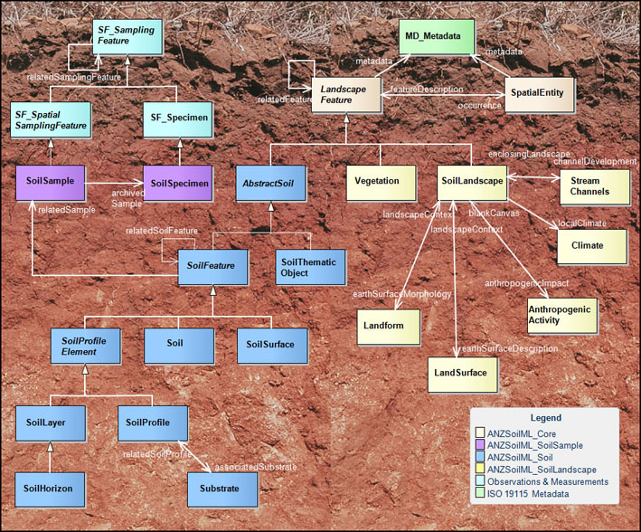
The ANZSoilML information model consists of four application schema covering soil samples, soil features, soil landscapes and a core package providing metadata and spatial information.
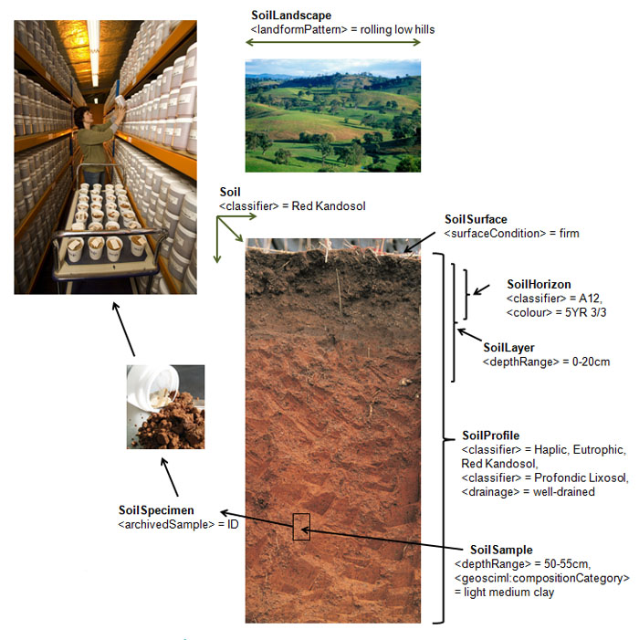
Below is an example of a Haplic, Eutrophic Red Kandasol from southern NSW, showing ANZSoilML features (bold) and a subset of available ANZSoilML properties (<>) and values.
ANZSoilML Resources
ANZSoilML UML
ANZSoilML Instance Documents
ANZSoilML Soil Profile instance
ANZSoilML Soil Horizon instance
ANZSoilML enquries
Mr Peter Wilson
Manager, National Soil Information
Telephone: 02 6246 5860
peter.wilson@csiro.au