Rudosols [RU]
Concept
This order is designed to accommodate soils that have negligible pedologic organisation. They are usually young soils in the sense that soil forming factors have had little time to pedologically modify parent rocks or sediments. The component soils can obviously vary widely in terms of texture and depth; many are stratified and some are highly saline. Data on some of them are very limited.
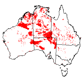
Distribution of Rudosols in Australia.
Soil Profile (View type example photo
of Stratic Rudosol).
Definition
Soil with negligible (rudimentary) pedologic organisation apart from (a) minimal development of an Al horizon or (b) the presence of less than 10% of B horizon material (including pedogenic carbonate) in fissures in the parent rock or saprolite. The soils are apedal or only weakly structured in the A1 horizon and show no pedological colour changes apart from the darkening of an A1 horizon. There is little or no texture or colour change with depth unless stratified or buried soils are present.
Comment
By definition, these soils will grade to Tenosols, so before deciding on the order check the Tenosol definition as it will often be a matter of judgement as to which order a particular soil is best placed. Hydrosols are excluded on the basis that these will normally show some pedological development eg. mottling. A particular problem with the definition and subdivision of Rudosols is the difficulty in distinguishing between soil and 'non-soil', (see also 'What do we classify?'). In many instances they are classified on the basis of the nature of AC or C horizon materials or other substrates because these are the dominating features of the profile. It also follows that there may be difficulties in deciding if a soil is best classified as an Anthroposol or be regarded as an anthropic Rudosol because the little-altered soil parent material may be human-made.
Suborders
- Soils that are not highly saline (EC < 2 dSm-1; 1:5 H2O) and dominantly consist of gypsum crystals which are sand-sized or finer. Hypergypsic [FJ]
- Soils that are highly saline (EC > 2 dSm-1; 1:5 H2O), often salt-encrusted, frequently stratified, but do not have a permanent or seasonal water table and do not show any evidence, such as mottling, of episodic wetting by groundwater. Hypersalic [CS]
- Soils in which the profile, with the possible exception of the A horizon, is calcareous, either loose or only weakly coherent both moist and dry, and consists dominantly of sand-sized fragments of shells and other aquatic skeletons (identifiable under a 10x hand lens). Shelly [EL]
- Soils in which the upper 0.5 m (or less if the profile is shallower) consists dominantly of carbic materials. Carbic [HG]
- Soils in which at least the upper 0.5 m of the profile is not or only slightly gravelly (<10% >2mm) throughout, either loose or only weakly coherent both moist and dry, and the texture is sandy (ie. S-LS-CS, up to 10% clay). Aeolian cross-bedding may be present but there is little if any evidence of other stratification or buried soils. Arenic [AO]
- Soils in which at least the upper 0.5m of the profile consists dominantly of unconsolidated mineral materials which are not or only slightly gravelly (<10% >2mm). Aeolian cross-bedding may be present but there is little if any evidence of other stratification or buried soils. If the soil material is sandy (ie. S-LS-CS, up to 10% clay) it is coherent. Lutic [GV]
- Soils in which at least the upper 0.5m of the profile consists dominantly of unconsolidated mineral materials which are distinct, not or only slightly gravelly (<10% >2mm) sedimentary layers or buried soils but salinity is not high (EC<2 dSm-1; 1:5 H20). Stratic [ER]
- Soils in which at least the upper 0.5m of the profile consists dominantly of unconsolidated mineral materials which are gravelly (>10% >2mm). The gravel may occur as distinct layers, or be uniformly or irregularly distributed. Clastic [HH]
- Other soils that are underlain within 0.5m of the surface by a calcrete pan; hard unweathered rock or other hard materials; or partially weathered or decomposed rock or saprolite. Leptic [CY]
Comment
The Hypergypsic soils normally occur as gypsum lunettes and the Hypersalic soils are most common in many of the saline playas of the arid interior of the continent. Shelly soils are widespread as coastal and near coastal dunes in southern and south-western Australia, while the Carbic soils have so far only been recorded in the Sydney basin, NSW. The Arenic suborder mainly caters for the widespread siliceous dunes and sandsheets of arid Australia, and for some usually recently deposited fluvial sands and very young coastal sands such as foredunes. The Lutic soils include loamy or clayey aeolian forms common on some of the many lunettes in southern Australia, as well as other coherent soils formed on sandy, loamy or clayey fluvial deposits, or easily weathered rocks. The Stratic and Clastic soils are most common on alluvial terraces, plains and fans.
The most commonly recorded suborder is the Leptic class (44% of the soils classified to date) and these are mostly shallow profiles overlying hard or weathered rock.
Great Groups
No great groups are presently proposed for the Hypergypsic, Shelly, Carbic, Arenic, Lutic or Stratic suborders as data are very limited.
Hypersalic Rudosols
- Soils in which sulfuric material (at least 15 cm thick) occurs within the upper 1.5m of the profile. Sulfuric [EV]
- Soils in which both monosulfidic material and sulfuric material (at least 15 cm thick) occur within the upper 1.5m of the profile. Monosulfidic - Sulfuric [IW]
- Soils in which sulfidic materials occur within the upper 1.5 m of the profile. Sulfidic [EU]
- Soils in which both monosulfidic material and hypersulfidic material occur within the upper 1.5m of the profile. Monohypersulfidic [IX]
- Other soils in which hypersulfidic material occurs within the upper 1.5m of the profile. Hypersulfidic [IZ]
- Soils in which both monosulfidic material and hyposulfidic material occur within the upper 1.5m of the profile. Monohyposulfidic ([JA]
- Other soils with hyposulfidic material within the upper 1.5m of the profile. Hyposulfidic [JC]
- A gypsic horizon occurs within the upper 0.5 m of the profile. Gypsic [BZ]
- The major part of the upper 0.5 m of the profile consists of materials dominated (>50%) by halite crystals. Halic [CC]
Note: The sulfuric Great Group can be replaced by the following Great Group where appropriate evidence is available:
Note: The sulfidic Great Group can be replaced by the following Great Groups where appropriate evidence is available:
Clastic Rudosols
- Soils in which the gravel consists dominantly of little-weathered tephric materials. Tephric [HF]
- Soils in which the gravelly materials contain a ferric horizon. Ferric [BU]
- Soils in which the gravelly materials contain a bauxitic horizon. Bauxitic [AS]
- Soils in which the gravel consists of usually unsorted material with a wide size range. It is largely colluvial mass movement debris, including scree and talus, and landslide, mudflow and creep deposits. Colluvic [HI]
- Soils in which the gravel consists dominantly of mostly rounded materials that have been transported by streams or by wave action. Fluvic [BX]
- Other soils in which the unconsolidated mineral materials are dominated by gravel which mostly consists of rock or mineral fragments. Lithosolic [HJ]
Leptic Rudosols
- The soil material directly overlies a red-brown hardpan. Duric [BJ]
- The soil material contains a ferric horizon and directly overlies ferricrete, petroreticulate or a petroferric horizon. Ferric-Petroferric [GE]
- The soil material directly overlies ferricrete, petroreticulate, or a petroferric horizon. Petroferric [EA]
- The soil material directly overlies a calcrete pan. Petrocalcic [DZ]
- The soil material directly overlies hard rock. Lithic [CZ]
- The soil material directly overlies partially weathered or decomposed rock or saprolite. Paralithic [DU]
Comment
The Tephric soils in the Clastic suborder are known only from some of the Pliocene to Holocene Newer Volcanics in south western Victoria. They have not weathered sufficiently for them to be recognised as possessing andic properties, or to meet the requirements for the Tenosols.
In the Petrocalcic great group of the Leptic suborder the calcrete occurs as a substrate material that may or may not be the parent material of the soil.
Subgroups
No subgroups are yet proposed for the Shelly and Carbic suborders. The following subgroups will be used for the remaining suborders where relevant.
- The major part of the soil materials is strongly acid. Acidic [AI]
- The soil materials are not calcareous and the major part is not strongly acid. Basic [AR]
- At least some part of the soil materials is calcareous. Calcareous [BC]
Comment
In the Calcareous subgroups the carbonate present is usually not pedogenic, but is in effect part of the parent material, either of aeolian or residual origin. However, in Calcarosol landscapes it is inevitable that some young alluvial deposits may contain transported pedogenic carbonate nodules, and hence soils developed on such deposits should be regarded as Rudosols rather than Calcarosols. The presence of sedimentary layering will usually be diagnostic. Small amounts of pedogenic carbonate (<10%) may occur in fissures in the parent rock or saprolite of some Leptic Rudosols.
A similar situation arises in the case of the Calcareous Hypergypsic soils. These usually occur on lunettes, and thus the carbonate is also of aeolian origin. Whether or not pedogenic accumulations also occur will probably depend on the age of the lunettes. If so, the soils will be more appropriately classified as Hypergypsic Calcarosols. The distinction between Shelly Rudosols and Shelly Calcarosols will similarly be based on the absence or presence of pedogenic carbonate.
Family Criteria
There are obvious problems in applying the usual family criteria to Rudosols. By definition, A horizons have minimal development and hence may be difficult to recognise, and in some classes the texture is set by definition, e.g. the Arenic suborder is sandy. It has been decided not to use A horizon thickness, and not refer to any classes for subsoil texture. By definition, subsoil texture must be the same as surface soil unless the profile is stratified, in which case the situation is usually too complex to manage satisfactorily. Similarly, the term soil depth is used only in the case of the Leptic suborder, where only two classes will be required. Elsewhere the term becomes meaningless. Gravel content of surface soil can be usefully used for several suborders. In general, surface soil in this context will probably be in the range of 0.1-0.2 m in thickness.
Gravel of surface soil (visual estimate)
| Non-gravelly | [E] | : < 2% |
|---|---|---|
| Slightly gravelly | [F] | : 2 - < 10% |
| Gravelly | [G] | : 10 - < 20% |
| Moderately gravelly | [H] | : 20 - 50% |
| Very gravelly | [I] | : > 50% |
A1 horizon texture
| Sandy | [K] | : S-LS-CS (up to 10% clay) |
|---|---|---|
| Loamy | [L] | : SL-L (10-20% clay) |
| Clay loamy | [M] | : SCL-CL (20-35% clay) |
| Silty | [N] | : ZL-ZCL (25-35% clay and silt 25% or more) |
| Clayey | [O] | : LC-MC-HC (> 35% clay) |
Soil depth
| Very shallow | [T] | : < 0.25 m |
|---|---|---|
| Shallow | [U] | : 0.25 - < 0.5 m |