Hydrosols [HY]
Concept
This order is designed to accommodate a range of seasonally or permanently wet soils and thus there is some diversity within the order. The key criterion is saturation of the greater part of the profile for prolonged periods (2-3 months) in most years. The soils may or may not experience reducing conditions for all or part of the period of saturation, and thus manifestations of reduction and oxidation such as 'gley' colours and ochrous mottles may or may not be present.
Saturation by a water table may not necessarily be caused by low soil permeability. Often site drainage will be the most important factor, while in other well-known cases tidal influence is dominant. The relevant Field Handbook drainage classes are very poorly and poorly drained.
Several major classes of soils are excluded because it is considered their other profile characteristics are of greater significance than wetness. These are the Organosols, Podosols and Vertosols. Although some Hydrosols are dominated by organic materials (see Intertidal Hydrosols below), it is thought that because of their unique nature (ie. largely consisting of mangrove debris that is regularly inundated by saline tidal waters), it is more appropriate to classify them as organic Hydrosols rather than as a class of Organosols that occur in a mangrove environment.
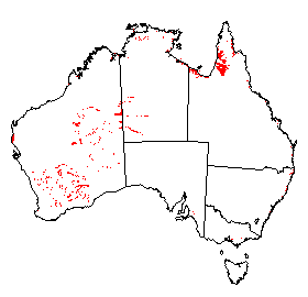
Distribution of Hydrosols in Australia.
Soil Profile (View type example photo
of Redoxic Hydrosol).
Definition
Soils other than Organosols, Podosols and Vertosols in which the greater part of the profile is saturated for at least 2-3 months in most years.
Comment
The approach taken in this concept of 'wet' soils differs from more traditional usage in that reducing conditions are not emphasised. The rationale for the present approach is based on the assumption that saturation affects soil properties irrespective of whether or not reducing conditions are present. Obvious examples are those relating to certain physical and engineering properties, which result in limitations to the use of a soil eg. trafficability, etc.
A further reason for not making reducing conditions mandatory is the well-known difficulty in identifying such conditions, which are often of a temporal nature and sporadic in spatial distribution. It is widely recognised that the traditional use of 'gley' colours and particular kinds of mottling are not universally indicative of a saturated condition or its duration. In particular, mottles or other segregations can be relict. Another problem in identification of reducing conditions, is the experience that various indicator dyes such as a,a-dipyridyl (Childs & Clayden 1986) may be unreliable.
It will also be apparent that the concept adopted for Hydrosols will normally exclude the pseudo (or surface water) gley class commonly distinguished in several European classification schemes. These soils have a perched water table usually caused by a slowly permeable horizon or layer within the soil profile.
A difficult question arises as to how artificially drained soils are best treated. In many cases drainage will merely lower the water table to depths which permit the successful growth of particular plants. Such depths may still be relatively shallow eg. 0.5 - 1 m, and capillary rise may result in wet soil conditions to variable heights above the new water table. Additionally, the topographic situation and/or the climatic environment may mean that drainage merely reduces the period of saturation. If drainage is such that saturation no longer occurs for appropriate periods in the relevant parts of the profile, the soil can strictly no longer be considered a Hydrosol. Possibly a 'drained' phase may be appropriate in some such circumstances.
In the case of irrigated soils, the main example is when more or less permanent flood irrigation is employed to grow rice. This would be expected to change, for example, a Chromosol to a Chromosolic Hydrosol. It should be noted that the definition of the order is deliberately somewhat equivocal in that the duration and frequency of saturation of a precise section of the profile are not specifically defined. Lack of water table data is one reason, but it is also thought that a degree of flexibility is required for the definition. It is recognised that the extent of soil wetness can seldom be assessed by a single inspection of a particular site. However, in the author's experience judicious questioning of people with local knowledge, together with the soil scientist's assessment of soil and site drainage and climatic environment, can usually achieve a satisfactory resolution of the problem.
Suborders
- Soils of tidal estuaries, bays and river deltas that experience permanent inundation between Mean Low Water Springs (MLWS) and 2.5m below MLWS. Subtidal [IU]
- Soils of inland water bodies that are located between the water surface and 2.5m below the surface. Subaqueous [IV]
- Soils of intertidal flats (often colonised by mangroves) that experience regular saline tidal inundation of mostly high frequency. Intertidal [CW]
- Soils of supratidal flats (normally bare of vegetation except for halophytes such as samphires), often salt-encrusted. Tidal inundation is infrequent (spring tides) but a saline water table is present at shallow depths. Supratidal [EW]
- Soils of the extratidal zone (usually supporting grassland). Tidal inundation is infrequent and achieved only by exceptional storm or cyclonic tides (above high spring tides). Freshwater inundation is seasonally common. Extratidal [BT]
- Soils of the saline playa lakes (including coastal salinas and continental playas) which are usually bare and when dry are frequently halite - or gypsum-encrusted, or with a sparse cover of halophytes such as samphires. The continental playas are infrequently inundated with fresh water, but a shallow saline ground water table is usually present in all types throughout the year, mostly within 50 cm of the surface. Hypersalic [CS]
- Salinised soils caused by a rising saline water table or by saline seepage resulting from near-surface lateral movement (through flow) of water and salt from higher landscape positions. Such areas may be bare and salt-encrusted, often have a soft fluffy surface, and may or may not have a sparse cover of halophytic plants. Water table conductivity will usually be in the range of 2-50 dSm-1; soil salinity may vary widely due to capillary concentration at or near the surface, and subsequent leaching of salt by seasonal precipitation. Salic [EG]
- Other soils with a seasonal or permanent water table and in which the major part of the solum (or the subsoil if the profile is stratified) is mottled. Redoxic [ED]
- Other soils with a seasonal or permanent water table and in which the major part of the solum (or the subsoil if the profile is stratified) is whole coloured. Oxyaquic [DT]
Comment
The features used in the definitions of the first seven suborders differ from those used elsewhere in the classification in that the classes are essentially based on the frequency of tidal or freshwater inundation and the nature of the soil surface. This is thought to be an appropriate approach as the key feature of Hydrosols is their wetness. The references in parenthesis to vegetation in the definitions are merely indicating accessory properties of the class which may aid identification of what are essentially wetness criteria, for example, the presence of certain mangrove species will normally indicate a regular frequency of tidal wetting. Although it may be difficult to identify the Extratidal suborder by the low frequency of tidal inundation, there is usually a distinct boundary between this zone and the often bare, salt-encrusted Supratidal zone. This boundary is commonly marked by a low (0.1 - 0.2m) 'scarp'. The three tidal-affected suborders are largely based on data from Cook and Mayo (1977).
For the purposes of soil classification, hydrosols located within Intermittently Closed and Open Lakes and Lagoons (ICOLLS) are considered to be tidal.
Where inundation at the perimeter of larger water bodies is cyclical as a result of seiches or from variability in rainfall and runoff, it is often difficult to decide if currently submerged soils are either Subaqueous, Redoxic or Oxyaquic. Their classification will depend on conditions at the time of sampling and knowledge of the frequency and duration of any drying on exposure. With some submerged soils, evidence of prior surface soil aeration such as the development of mottles, soil structure or very low pH suggests that the soils are not Subaqueous, i.e. subject to permanent saturation. If the period of exposure is insufficient to allow substantial soil aeration and there is no evidence of oxidation and drying, then the soils are considered to be Subaqueous.
In the Salic suborder the salinisation may or may not be human-induced. Saline water tables may arise as a result of a sequence of wetter-than-average years, or they may result from activities such as a tree clearing and/or unwise irrigation practices. With time it is likely that some of the human-induced saline soils will tend to those of the Hypersalic suborder, as evidenced in some of the saline valleys of the Western Australian wheat belt. It also follows that a wide range of soils is likely to occur in the Salic suborder.
In the Redoxic and Oxyaquic suborders water tables are normally non-saline. However exceptions may occur where these soils are underlain by sulfuric and/or sulfidic materials, as described by Walker (1972). It should be noted that the use of mottling as a diagnostic criterion in the former suborder does not necessarily imply that oxidising and reducing conditions are currently occurring in the soil in most years.
Of the Hydrosol profiles available for classification, 62% were Redoxic and 29% were Oxyaquic.
Great Groups
Because of lack of data in the first seven suborders, further studies may lead to additional great groups.
Subtidal, Intertidal and Subaqueous Hydrosols
Conventional horizon nomenclature is inapplicable to these soils, hence the use of arbitrary depth limits.
- Soils in which sulfuric material (at least 15 cm thick) occurs within the upper 1.5m of the profile. Sulfuric [EV]
- Soils in which both monosulfidic material and sulfuric material (at least 15 cm thick) occur within the upper 1.5m of the profile. Monosulfidic - Sulfuric [IW]
- Soils in which sulfidic materials occur within the upper 1.5 m of the profile. Sulfidic [EU]
- Soils in which both monosulfidic material and hypersulfidic material occur within the upper 1.5m of the profile. Monohypersulfidic [IX]
- Other soils which are dominated by organic materials to a depth of 0.5m and which have hypersulfidic material within the upper 1.5m of the profile. Histic-Hypersulfidic [IY]
- Other soils in which hypersulfidic material occurs within the upper 1.5m of the profile. Hypersulfidic [IZ]
- Soils in which both monosulfidic material and hyposulfidic material occur within the upper 1.5m of the profile. Monohyposulfidic ([JA]
- Other soils which are dominated by organic materials to a depth of 0.5m and which have hyposulfidic material within the upper 1.5m of the profile. Histic-Hyposulfidic [IY]
- Other soils with hyposulfidic material within the upper 1.5m of the profile. Hyposulfidic [JC]
- Other soils which are dominated by organic materials to a depth of 0.5m. Histic [CF]
- The soil materials to a depth of 0.5 m are dominated by other organic-rich (non-vegetative) materials such as faunal debris. Faunic [FW]
- The soil materials to a depth of 0.5 m are dominantly calcareous. Epicalcareous [FY]
- The soil materials to a depth of 0.5 m are dominantly clay-sized. Argillaceous [AQ]
- The soil materials to a depth of 0.5 m are dominantly silt-sized. Lutaceous [FX]
- The soil materials to a depth of 0.5 m are dominantly sand-sized. Arenaceous [BV]
Note: The sulfuric great group can be replaced by the following great group where appropriate evidence is available:
Note: The sulfidic great group can be replaced by the following great groups where appropriate evidence is available:
Supratidal Hydrosols
- Soils in which sulfuric material (at least 15 cm thick) occurs within the upper 1.5m of the profile. Sulfuric [EV]
- Soils in which both monosulfidic material and sulfuric material (at least 15 cm thick) occur within the upper 1.5m of the profile. Monosulfidic - Sulfuric [IW]
- Soils in which sulfidic materials occur within the upper 1.5 m of the profile. Sulfidic [EU]
- Soils in which both monosulfidic material and hypersulfidic material occur within the upper 1.5m of the profile. Monohypersulfidic [IX]
- Other soils in which hypersulfidic material occurs within the upper 1.5m of the profile. Hypersulfidic [IZ]
- Soils in which both monosulfidic material and hyposulfidic material occur within the upper 1.5m of the profile. Monohyposulfidic ([JA]
- Other soils with hyposulfidic material within the upper 1.5m of the profile. Hyposulfidic [JC]
- Soils with a gypsic horizon within the upper 0.5 m of the profile. Gypsic [BZ]
- Soils in which the major part of the upper 0.5 m of the profile is calcareous. Epicalcareous [FY]
- Soils in which the major part of the upper 0.5 m of the profile is mottled. Mottled [DQ]
- Soils in which the major part of the upper 0.5 m of the profile is whole coloured. Haplic [CD]
Note: The sulfuric great group can be replaced by the following great group where appropriate evidence is available:
Note: The sulfidic great group can be replaced by the following great groups where appropriate evidence is available:
Hypersalic Hydrosols
- Soils in which sulfuric material (at least 15 cm thick) occurs within the upper 1.5m of the profile. Sulfuric [EV]
- Soils in which both monosulfidic material and sulfuric material (at least 15 cm thick) occur within the upper 1.5m of the profile. Monosulfidic - Sulfuric [IW]
- Soils in which sulfidic materials occur within the upper 1.5 m of the profile. Sulfidic [EU]
- Soils in which both monosulfidic material and hypersulfidic material occur within the upper 1.5m of the profile. Monohypersulfidic [IX]
- Other soils in which hypersulfidic material occurs within the upper 1.5m of the profile. Hypersulfidic [IZ]
- Soils in which both monosulfidic material and hyposulfidic material occur within the upper 1.5m of the profile. Monohyposulfidic ([JA]
- Other soils with hyposulfidic material within the upper 1.5m of the profile. Hyposulfidic [JC]
- Soils with a gypsic horizon within the upper 0.5 m of the profile. Gypsic [BZ]
- Soils in which the major part of the upper 0.5 m of the profile consists of materials dominated (> 50%) by halite crystals. Halic [CC]
- Soils in which the major part of the upper 0.5 m of the profile is calcareous. Epicalcareous [FY]
- Soils in which the major part of the upper 0.5 m of the profile is mottled. Mottled [DQ]
- Soils in which the major part of the upper 0.5 m of the profile is whole coloured. Haplic [CD]
Note: The sulfuric great group can be replaced by the following great group where appropriate evidence is available:
Note: The sulfidic great group can be replaced by the following great groups where appropriate evidence is available:
Extratidal and Salic Hydrosols
The provision of great groups for these suborders is incomplete because of lack of data. High salt contents usually tend to obliterate the original morphology, but where this can still be identified, great groups may be established on this basis.
- Soils in which sulfuric material (at least 15 cm thick) occurs within the upper 1.5m of the profile. Sulfuric [EV]
- Soils in which both monosulfidic material and sulfuric material (at least 15 cm thick) occur within the upper 1.5m of the profile. Monosulfidic - Sulfuric [IW]
- Soils in which sulfidic materials occur within the upper 1.5 m of the profile. Sulfidic [EU]
- Soils in which both monosulfidic material and hypersulfidic material occur within the upper 1.5m of the profile. Monohypersulfidic [IX]
- Other soils in which hypersulfidic material occurs within the upper 1.5m of the profile. Hypersulfidic [IZ]
- Soils in which both monosulfidic material and hyposulfidic material occur within the upper 1.5m of the profile. Monohyposulfidic ([JA]
- Other soils with hyposulfidic material within the upper 1.5m of the profile. Hyposulfidic [JC]
- Soils with a petroferric horizon within the solum. Petroferric [EA]
- Soils that are calcareous throughout the solum, or at least below the A1 horizon or to a depth of 0.2 m if the A1 horizon is only weakly developed, and do not have a clear or abrupt textural B horizon. Calcarosolic [CB]
- Soils with a clear or abrupt textural B horizon and the major part of the upper 0.2 m of the B2 horizon is strongly acid. Kurosolic [CX]
- Soils with a clear or abrupt textural B horizon which is sodic and not strongly acid in the major part of the upper 0.2 m of the B2 horizon. Sodosolic [EQ]
- Other soils with a clear or abrupt textural B horizon and the pH in the major part of the upper 0.2 m of the B2 horizon is not strongly acid. Chromosolic [BG]
- Soils with structured B2 horizons and which apart from wetness fulfil the requirements for Dermosols. Dermosolic [FQ]
- Other soils with B2 horizons and which apart from wetness fulfil the requirements for Kandosols. Kandosolic [FR]
- Soils which apart from wetness fulfil the requirements for Tenosols. Tenosolic [GT]
- Soils which apart from wetness fulfil the requirements for Rudosols. Rudosolic [GR]
Note: The sulfuric great group can be replaced by the following great group where appropriate evidence is available:
Note: The sulfidic great group can be replaced by the following great groups where appropriate evidence is available:
Redoxic and Oxyaquic Hydrosols
The following great groups will not all be relevant for each of these two suborders. For example, the Rudosolic great group will not be required for the Redoxic suborder.
- Soils in which sulfuric material (at least 15 cm thick) occurs within the upper 1.5m of the profile. Sulfuric [EV]
- Soils in which both monosulfidic material and sulfuric material (at least 15 cm thick) occur within the upper 1.5m of the profile. Monosulfidic - Sulfuric [IW]
- Soils in which sulfidic materials occur within the upper 1.5 m of the profile. Sulfidic [EU]
- Soils in which both monosulfidic material and hypersulfidic material occur within the upper 1.5m of the profile. Monohypersulfidic [IX]
- Other soils in which hypersulfidic material occurs within the upper 1.5m of the profile. Hypersulfidic [IZ]
- Soils in which both monosulfidic material and hyposulfidic material occur within the upper 1.5m of the profile. Monohyposulfidic ([JA]
- Other soils with hyposulfidic material within the upper 1.5m of the profile. Hyposulfidic [JC]
- Soils with a petroferric horizon within the solum. Petroferric [EA]
- Soils which are calcareous throughout the solum, or at least below the A1 or Ap horizon or to a depth of 0.2 m if the A1 horizon is only weakly developed, and do not have a clear or abrupt textural B horizon. Calcarosolic [CB]
- Soils with a clear or abrupt textural B horizon and the major part of the upper 0.2 m of the B2 horizon is strongly acid. Kurosolic [CX]
- Soils with a clear or abrupt textural B horizon which is sodic and not strongly acid in the major part of the upper 0.2 m of the B2 horizon. Sodosolic [EQ]
- Other soils with a clear or abrupt textural B horizon and the pH in the major part of the upper 0.2 m of the B2 horizon is not strongly acid. Chromosolic [BG]
- Soils with structured B2 horizons and which apart from wetness fulfil the requirements for Dermosols. Dermosolic [FQ]
- Other soils with B2 horizons and which apart from wetness fulfil the requirements for Kandosols. Kandosolic [FR]
- Soils which apart from wetness fulfil the requirements for Tenosols. Tenosolic [GT]
- Soils which apart from wetness fulfil the requirements for Rudosols. Rudosolic [GR]
Note: The sulfuric great group can be replaced by the following great group where appropriate evidence is available:
Note: The sulfidic great group can be replaced by the following great groups where appropriate evidence is available:
Subgroups
No subgroups for the Subtidal, Subaqueous, Supratidal, Extratidal and Hypersalic Hydrosols are formally proposed at present because of insufficient data.
Subgroups of Intertidal Hydrosols
The following three subgroups will only be applicable to the Histic-Hypersulfidic and Histic-Hyposulfidic great groups.
- Soils in which the organic materials are dominated (about 75% by volume) by fibric peat. Fibric [BW]
- Soils in which the organic materials are dominated by hemic peat. Hemic [CE]
- Soils in which the organic materials are dominated by sapric peat. Sapric [EH]
Subgroups of Salic Hydrosols
The following three subgroups have been identified for several great groups in the Salic suborder. Other possibly relevant subgroups may be found listed below in the subgroups for the Redoxic and Oxyaquic suborders.
- Soils with sulfidic materials in the A or near surface horizons and which directly overlie a calcrete pan. Episulfidic-Petrocalcic [HM]
- Other soils with sulfidic materials in the A or near surface horizons. Episulfidic [HL]
- Other soils that directly overlie a calcrete pan. Petrocalcic [DZ]
Subgroups of Redoxic and Oxyaquic Hydrosols
It is thought that the following subgroups will cater for most situations, although obviously some will not be relevant for particular great groups. As examples, the Acidic subgroups will not be required for the Kurosolic great groups, nor the Sodic and Natric classes for the Sodosolic great group. Although presently not listed, a Petrocalcic subgroup may be required for the Calcarosolic great group. If so, a definition is available above. Some additional subgroups will be required for the Sulfuric and Sulfidic great groups as knowledge of these soils increases eg. a possible subdivision could be based on the nature of the soil profile above the sulfuric or sulfidic materials which commonly occur as a D horizon. "In the case of the Rudosolic and Tenosolic great groups, the most appropriate subgroups will be those used for the relevant suborders and great groups of Rudosols and Tenosols."
- Soils that have been partly modified by high temperature burning of organic materials. Such soils have surface layers that comprise >20% of fusic material. Fusic [IT]
- Soils with a peaty horizon and a thin ironpan which occurs within or directly underlying the B horizon. Peaty-Placic [GD]
- Other soils with a peaty horizon Peaty [DW]
- Soils with a humose horizon and a B2 horizon in which the major part has an exchangeable Ca/Mg ratio of less than 0.1. Humose-Magnesic [CL]
- Soils with a humose horizon and the major part of the B2 horizon is strongly acid. Humose-Acidic [GY]
- Soils with a humose horizon and at least some part of the B or BC horizon is calcareous. Humose-Calcareous [GU]
- Soils with a humose horizon and a conspicuously bleached A2 horizon. Humose-Bleached [EY]
- Other soils with a humose horizon. Humose [CK]
- Soils with a melacic horizon and a B2 horizon in which the major part has an exchangeable Ca/Mg ratio of less than 0.1. Melacic-Magnesic [DH]
- Soils with a melacic horizon and a conspicuously bleached A2 horizon. Melacic-Bleached [EZ]
- Other soils with a melacic horizon. Melacic [DG]
- Soils with a melanic horizon and a conspicuously bleached A2 horizon. Melanic-Bleached [DL]
- Soils with a melanic horizon and a B horizon in which at least 0.3m has vertic properties. Melanic-Vertic [DN]
- Soils with a melanic horizon and the major part of the B2 horizon is strongly acid. Melanic-Acidic [FV]
- Other soils with a melanic horizon. Melanic [DK]
- Soils with a conspicuously bleached A2 horizon and a B horizon in which at least 0.3m has vertic properties. Bleached-Vertic [BB]
- Other soils with a B horizon in which at least 0.3m has vertic properties. Vertic [EX]
- Soils with a ferric horizon within the solum and a B2 horizon in which the major part is strongly acid. Ferric-Acidic [GW]
- Soils with a ferric horizon within the solum and a B horizon in which at least the lower part is sodic. Ferric-Sodic [HC]
- Soils with a conspicuously bleached A2 horizon and a ferric horizon within the solum. Bleached-Ferric [AV]
- Other soils with a ferric horizon within the solum. Ferric [BU]
- Soils with a manganic horizon within the solum and a B2 horizon in which the major part is strongly acid.Manganic-Acidic [GX]
- Soils with a conspicuously bleached A2 horizon and a manganic horizon within the solum. Bleached-Manganic [AY]
- Other soils with a manganic horizon within the solum. Manganic [DC]
- Soils with a hard siliceous pan in the lower A and/or upper B horizon. Silpanic [EM]
- Soils in which the major part of the B2 horizon is strongly acid and at least the lower part is sodic. Acidic-Sodic [HO]
- Soils with a conspicuously bleached A2 horizon and a B2 horizon in which the major part is strongly acid. Bleached-Acidic [AU]
- Other soils with a B2 horizon in which the major part is strongly acid. Acidic [AI]
- Soils that have an exchangeable Ca/Mg ratio of less than 0.1 in the major part of the B2 horizon, and the major part of the upper 0.2 m of the B2 horizon is sodic. Magnesic-Natric [GP]
- Soils in which the major part of the upper 0.2 m of the B2 horizon is sodic. Natric [FD]
- Soils with a conspicuously bleached A2 horizon and a B horizon in which at least the lower part is sodic. Bleached-Sodic [BA]
- Other soils with a B horizon in which at least the lower part is sodic Sodic [EO]
- Soils with a reticulate horizon below the B2 horizon. Reticulate [EF]
- Soils with a conspicuously bleached A2 horizon and a B2 horizon in which the major part has an exchangeable Ca/Mg ratio of less than 0.1. Bleached-Magnesic [AX]
- Soils with an exchangeable Ca/Mg ratio of less than 0.1 in the major part of the B2 horizon. Magnesic [DB]
- Other soils with a conspicuously bleached A2 horizon. Bleached [AT]
- Soils in which the major part of the B2 horizon is dystrophic. Dystrophic [AF]
- Soils in which the major part of the B2 horizon is mesotrophic. Mesotrophic [AG]
- Soils in which the major part of the B2 horizon is eutrophic but the B and BC horizons are not calcareous. Eutrophic [AH]
- Soils in which at least some part of the B or the BC horizon is calcareous. Calcareous [BC]
Family Criteria
The classes below are primarily for use in the Redoxic and Oxyaquic suborders, and possibly the Extratidal and Salic suborders. The criteria may be partly applicable to the Supratidal and Hypersalic suborders eg. using the terms surface soil and maximum subsoil texture. The different A horizon thickness criteria for great groups with a Clear or abrupt textural B horizon.allows alignment with their adjacent but drier equivalent soil orders.
A horizon thickness (for Chromosolic, Kurosolic and Sodosolic great groups)
| Thin | [A] | : < 0.1 m |
|---|---|---|
| Medium | [B] | : 0.1 - < 0.3 m |
| Thick | [C] | : 0.3 - 0.6 m |
| Very thick | [D] | : > 0.6 m |
A1 horizon thickness (for all other great groups)
| Thin | [A] | : < 0.1 m |
|---|---|---|
| Medium | [B] | : 0.1 - < 0.3 m |
| Thick | [C] | : 0.3 - 0.6 m |
| Very thick | [D] | : > 0.6 m |
Gravel of the surface and A1 horizon
| Non-gravelly | [E] | : < 2% |
|---|---|---|
| Slightly gravelly | [F] | : 2 - < 10% |
| Gravelly | [G] | : 10 - < 20% |
| Moderately gravelly | [H] | : 20 - 50% |
| Very gravelly | [I] | : > 50% |
A1 horizon texture
| Peaty | [J] | : see Peaty horizon |
|---|---|---|
| Sandy | [K] | : S-LS-CS (up to 10% clay) |
| Loamy | [L] | : SL-L (10-20% clay) |
| Clay loamy | [M] | : SCL-CL (20-35% clay) |
| Silty | [N] | : ZL-ZCL (25-35% clay and silt 25% or more) |
| Clayey | [O] | : LC - MC - HC (greater than 35% clay) |
B horizon maximum texture1
| Sandy | [K] | : S-LS-CS (up to 10% clay) |
|---|---|---|
| Loamy | [L] | : SL-L (10-20% clay) |
| Clay loamy | [M] | : SCL-CL (20-35% clay) |
| Silty | [N] | : ZL-ZCL (25-35% clay and silt 25% or more) |
| Clayey | [O] | : LC - MC - HC (greater than 35% clay) |
Soil depth
| Very shallow | [T] | : < 0.25 m |
|---|---|---|
| Shallow | [U] | : 0.25 - < 0.5 m |
| Moderate | [V] | : 0.5 - < 1.0 m |
| Deep | [W] | : 1.0 - < 1.5 m |
| Very deep | [X] | : 1.5 - 5 m |
| Giant | [Y] | : > 5 m |
1 This refers to the most clayey field texture category.