Sodosols [SO]
Concept
Soils with strong texture contrast between A horizons and sodicB horizons which are not strongly acid. Australia is noteworthy for the extent and diversity of sodic soils and the use of sodicity in Australian soil classification systems has recently been reviewed (Isbell, 1995).
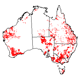
Distribution of Sodosols in Australia.
Soil Profile (View type example photo
of Grey Sodosol).
Definition
Soils with a clear or abrupt textural B horizon and in which the major part of the upper 0.2 m of the B2 horizon (or the major part of the entire B2 horizon if it is less than 0.2m thick) is sodic and not strongly acid. Hydrosols and soils with strongly subplastic upper B2 horizons are excluded.
Comment
There is convincing evidence from the Riverine Plain of south eastern Australia that soils with sodic clay B horizons (ESP 25-30) which are strongly subplastic behave very differently in terms of permeability to the more commonly found plastic sodic clay B horizons which are characterised by low to very low saturated hydraulic conductivity (McIntyre 1979). It is on this basis that subplastic sodic soils are excluded from Sodosols, because of their very different land use properties.
Strongly acid sodic soils are also excluded from Sodosols because they usually contain appreciable exchangeable aluminium (KC1 extractable) and thus should be unlikely to disperse.
It is usually possible to assess, in the field, the likelihood of a soil possessing a sodic B2 horizon. Such a criterion as the presence of a bleached A2 horizon with an abrupt change to a B2 horizon which has columnar or prismatic structure is a useful but not universal guide. A high pH value (>8.5) suggests sodicity, but the converse is not true. The soapy nature of the bolus produced in field texturing will also often suggest appreciable sodium (and/or magnesium) on the clay exchange complex.
Increasing experience in many parts of Australia is confirming that the Emerson dispersion test (Emerson 1967) and the modified version of Loveday and Pyle (1973) is a reliable guide to sodicity. It can be carried out as a preliminary test in the field, but should always be repeated under the better controlled conditions of the laboratory. In the initial test at least several fragments (each about 0.2 g or about 4 -5 mm diameter) are immersed in 100 ml of distilled water. The large water:soil ratio is necessary to remove any salt present in the aggregate. Also for this reason Emerson (1991) suggests that the classification for each test be made after 24 hours. For the remoulded test, use a 5 mm cube which can be obtained from the bolus used for determining field texture. This will be approximately in the plastic limit condition. Note that distilled water should be used to prepare the bolus.
Data from Loveday and Pyle (1973) and unpublished data available to the author suggest that a dispersive soil will usually indicate sodicity, ie. ESP of 6 or greater. The data of Murphy (1995) indicate that whereas Emerson class 1 and the more strongly dispersive soils of class 2 are a reliable indicator of sodicity, class 3 is a more variable predictor. Emerson classes of 5 or greater or a Loveday and Pyle score of zero strongly suggest soils are non-sodic. There is less evidence that the dispersion tests give a reliable indication of the degree of sodicity; factors such as extent of initial slaking and initial salt content in the aggregates, and the amount of magnesium and amount and form of aluminium on the exchange complex (Emerson 1994), can also influence the rapidity of dispersion. Nevertheless, the data of Loveday and Pyle measuring dispersion after 2 hours and 20 hours showed that the rate of dispersion could be used as a guide to ESP. This relationship does not apply to the subplastic soils of the Riverine Plain where subsoils with an ESP of 25-30 do not disperse unless remoulded (Blackmore 1976). Other anomalous results occur in a small minority of normal plastic soils in which dispersion will not occur even after remoulding in spite of an ESP much greater than 6 and a pH as high as neutral. In at least some of these non-dispersive soils the typical sodic soil morphology is present, ie. a conspicuously bleached A2 horizon abruptly overlying a B2 horizon with prismatic or columnar structure, suggesting the low hydraulic conductivity expected of a sodicB horizon.
Suborders
- The dominant colour class in the major part of the upper 0.2 m of the B2 horizon (or the major part of the entire B2 horizon if it is less than 0.2 m thick) is red. Red [AA]
- The dominant colour class is brown. Brown [AB]
- The dominant colour class is yellow. Yellow [AC]
- The dominant colour class is grey. Grey [AD]
- The dominant colour class is black. Black [AE]
Comment
The least common colour class is Yellow, with only 8% of the soils classified.
Great Groups
Some great group soils are much more common in certain colour suborders than others. The Duric and Pedaric great groups are known only from the arid zone, the former being particularly widespread in Western Australia and the latter in western Queensland and New South Wales, and in South Australia.
- Soils with a red-brown hardpan either within or directly underlying the B horizon. Duric [BJ]
- Soils with a petroferric horizon within the solum. Petroferric [EA]
- Soils with a B horizon that is not calcareous and which directly overlies a calcrete pan. Petrocalcic [DZ]
- Soils in which the upper 0.2 m of the B2 horizon (or the B2 horizon if it is less than 0.2 m thick) has a strong blocky or polyhedral structure in which average ped size is usually in the range of 5-20 mm. There is very weak adhesion between peds (when dry it is very easy to insert a spade into the upper B2 horizon). Salt contents are usually high, resulting in weak dry strength and a bulk density of about 1.3 t m-3 or less. In some soils the B2 horizons may be weakly subplastic. A common feature (but not diagnostic) of the overlying A horizons is the presence of a band of vesicular pores near the surface or on the underside of any surface flake. Pedaric [BK]
- Soils with fine earth effervescence (1M HCl) throughout the solum. Effervescent [IE]
- Soils in which the major part of the upper 0.2 m of the B2 horizon is mottled and has an ESP between 6 and <15. Mottled-Subnatric [FN]
- Other soils in which the major part of the upper 0.2 m of the B2 horizon has an ESP between 6 and <15. Subnatric [ES]
- Soils in which the major part of the upper 0.2 m of the B2 horizon is mottled and has an ESP between 15 and 25. Mottled-Mesonatric [FO]
- Other soils in which the major part of the upper 0.2 m of the B2 horizon has an ESP between 15 and 25. Mesonatric [DP]
- Soils in which the major part of the upper 0.2 m of the B2 horizon is mottled and has an ESP greater than 25. Mottled-Hypernatric [FP]
- Other soils in which the major part of the upper 0.2 m of the B2 horizon has an ESP greater than 25. Hypernatric [CR]
Comment
Non-mottled soils were found to be twice as common (64%) as mottled forms and Subnatric soils accounted for 53% of those classified.
Subgroups
Not every subgroup defined below will be required or be appropriate for each great group of each suborder. Some possible attributes have not been used for various reasons, e.g. bleaching has not been used because the great majority of soils in the class probably are bleached. Structure has not been used because of the diverse range that is encountered in these particular soils.
- Soils with a humose horizon. Humose [CK]
- Soils with a melanic horizon and a B horizon in which at least 0.3m has vertic properties. Melanic-Vertic [DN]
- Other soils with a melanic horizon. Melanic [DK]
- Other soils with a B horizon in which at least 0.3m has vertic properties. Vertic [EX]
- Soils with a gypsic horizon within the B or BC horizon. Gypsic [BZ]
- Soils with a ferric horizon within the solum. Ferric [BU]
- Soils with a manganic horizon within the solum. Manganic [DC]
- Soils with a hard siliceous pan in the lower A and/or upper B horizon. Silpanic [EM]
- Soils with an exchangeable Ca/Mg ratio of less than 0.1 in the major part of the B2 horizon. Magnesic [DB]
- Soils in which the major part of the B2 horizon is dystrophic. Dystrophic [AF]
- Soils in which the major part of the B2 horizon is mesotrophic. Mesotrophic [AG]
- Soils in which the major part of the B2 horizon is eutrophic but the B and BC horizons are not calcareous. Eutrophic [AH]
- Soils in which the carbonate is evident only as a slight to moderate effervescence (1M HCl), and/or contain less than 2% soft finely divided carbonate, and have less than 20% hard carbonate nodules or concretions. Hypocalcic [CV]
- Soils with a calcareous horizon containing more than 50% of hardcalcrete fragments and/or carbonate nodules or concretions and/or carbonate-coated gravel. Lithocalcic [DA]
- Soils with a calcareous horizon containing 20-50% of hard calcrete fragments and/or carbonate nodules or concretions and/or carbonate-coated gravel. Supracalcic [FB]
- Soils with a calcareous horizon containing more than 20% of mainly soft, finely divided carbonate, and 0-20% of hard calcrete fragments and/or carbonate nodules or concretions, and/or carbonate-coated gravel. Hypercalcic [CQ]
- Other soils with a calcareous horizon. (See carbonate classes). Calcic [BD]
Comment
The calcareous classes above approximately correspond to those of Wetherby and Oades (1975) as follows: Hypocalcic - Class IV, Lithocalcic - Class III B and III C, Supracalcic - Class III B, Hypercalcic - Class III A, Calcic - Class I and IIIA. In the Lithocalcic and Supracalcic classes the coarse fragments may be >0.2 m in size and soft carbonate may or may not be present.
Approximately 50% of the soils classified in the data set were calcareous in the B or BC horizon, and a further 27% were Eutrophic.
Family Criteria
A horizon thickness
| Thin | [A] | : < 0.1 m |
|---|---|---|
| Medium | [B] | : 0.1 - < 0.3 m |
| Thick | [C] | : 0.3 - 0.6 m |
| Very thick | [D] | : > 0.6 m |
Gravel of surface and A1 horizon
| Non-gravelly | [E] | : < 2% |
|---|---|---|
| Slightly gravelly | [F] | : 2 - < 10% |
| Gravelly | [G] | : 10 - < 20% |
| Moderately gravelly | [H] | : 20 - 50% |
| Very gravelly | [I] | : > 50% |
A1 horizon texture
| Sandy | [K] | : S-LS-CS (up to 10% clay) |
|---|---|---|
| Loamy | [L] | : SL-L (10-20% clay) |
| Clay loamy | [M] | : SCL-CL (20-35% clay) |
| Silty | [N] | : ZL-ZCL (25-35% clay and silt 25% or more) |
B horizon maximum texture1
| Clay loamy | [M] | : SCL-CL (20-35% clay) |
|---|---|---|
| Silty | [N] | : ZL-ZCL (25-35% clay and silt 25% or more) |
| Clayey | [O] | : LC - MC - HC (> 35% clay) |
Soil depth
| Very shallow | [T] | : < 0.25 m |
|---|---|---|
| Shallow | [U] | : 0.25 - < 0.5 m |
| Moderate | [V] | : 0.5 - < 1.0 m |
| Deep | [W] | : 1.0 - < 1.5 m |
| Very deep | [X] | : 1.5 - 5 m |
| Giant | [Y] | : > 5 m |
1 This refers to the most clayey field texture category.